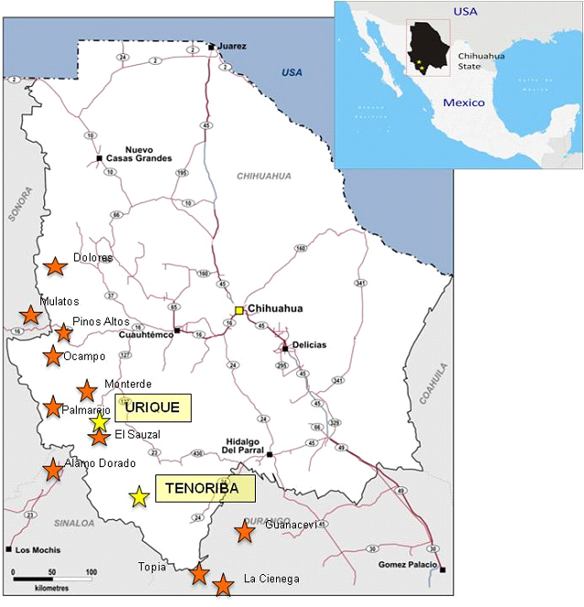
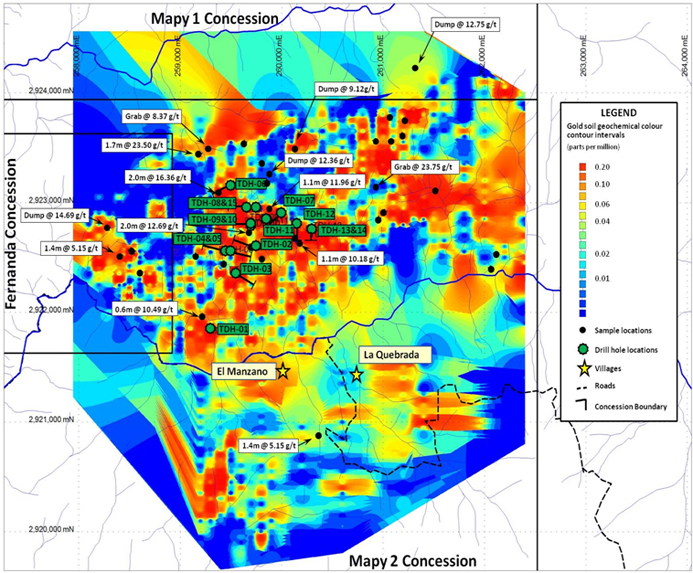
| Toronto, Canada (October 18, 2012) -- Mammoth Resources Corp. (TSX-V: MTH) is pleased to report the preliminary results of efforts to consolidate the historical data generated from the Tenoriba Property by the predecessor optioning party Masuparia Gold Corporation. The Tenoriba Property is located in the state of Chihuahua, Mexico only 100 kilometres south of the company's Urique Property (refer to Figure 1. Mammoth Resources - Project Location Map and press release dated July 3, 2012 with regards to terms of the company's option agreement on the Tenoriba Property). The consolidation work highlighted the presence of a large irregular shaped approximately 5.0 kilometre by 2.0 kilometres, generally east -- west striking soil gold anomaly with numerous surface rock samples assaying greater than 5.0 gram per tonne (g/t) gold up to as high as 23.75 g/t gold (refer to Figure 2. - Surface Rock Sample and Colour Contoured Gold Soil Map of the Tenoriba Property). The consolidation work was performed mainly from Masuparia's 2007-2008 exploration program which includes 1,893 soil samples, 90 stream samples and 686 rock surface samples. Mammoth President and CEO, Thomas Atkins, commented on the results of the consolidation work, stating: "Almost half of the two kilometre by five kilometre area of anomalous gold in soil results show values in excess of 0.2 parts per million, or 0.2 grams of gold per tonne, in soil. This anomalous area is very large and in addition to attractive gold in soil values, is supported throughout this same area by numerous surface rock samples ranging from five grams per tonne gold with many in excess of ten grams per tonne gold up to almost 24 grams per tonne gold. We're very encouraged by such a large geochemically anomalous footprint on the property and are eager to begin our field program to explore this area in greater detail with a focus on understanding the geological and structural controls to this attractive gold mineralization which remains open along strike to the east and the west." The gold in soil anomaly is frequently associated with other anomalous elements such as Silver, Copper, Lead, Zinc and Molybdenum. The consolidation work also includes the review of Masuparia's (2007 - 2008) 15 diamond drill holes totalling 2,570.4 metres of HQ & NQ size drill core. The company would also like to announce commencement of its 2012 surface sampling and mapping program on the Property. Mammoth's phase one field program will initially concentrate on re-logging the existing holes and verify the geology and previously interpreted mineralization controls. An effort will be made to correlate the surface and diamond drill geology with these same mineralization controls. Afterwards, the company plans to extend the surface mapping and sampling to area within the property beyond those explored by Masuparia in search of additional areas of alteration and/or mineralized with characteristics similar to those observed in the area of prior exploration. A camp facility, including historical core storage and core logging facilities exists on site, left behind by Masuparia. The phase one program is expected to take approximately three to four months to complete followed by analysis of results and a discussion on recommendations for future work. The company is well funded to execute this program. In the coming months the company looks forward to reporting on results from this 2012 field program at Tenoriba. About Mammoth Resources: Mammoth Resources (TSX-V: MTH) is a mineral exploration company focused on acquiring and defining precious metal resources in Mexico and other attractive mining friendly jurisdictions in the Americas. The Company has an option to acquire 100% of the Urique Property and the Tenoriba Property located in the Sierra Madre Precious Metal Belt in southwestern Chihuahua State, Mexico and continues to seek other option agreements on other properties it deems to host above average potential for economic concentrations of precious metals mineralization. Qualified Person / Quality Controls: Richard Simpson, P.Geo.,Vice-President Exploration for Mammoth Resources Corp. is Mammoth's Qualified Person, according to National Instrument 43-101, for the Tenoriba property and is responsible for any technical data mentioned in this news release. To find out more about Mammoth Resources and to sign up to receive future press releases, please visit the company's website at www.mammothresources.ca Neither the TSX Venture Exchange nor its Regulation Services Provider (as that term is defined in the policies of the TSX Venture Exchange) accepts responsibility for the adequacy or accuracy of this release. Forward Looking Information: This news release may contain or refer to forward-looking information. All information other than statements of historical fact that address activities, events or developments that the Company believes, expects or anticipates will or may occur in the future are forward-looking statements; examples include the listing of its shares on a stock exchange and establishing mineral resources. These forward-looking statements are subject to a variety of risks and uncertainties beyond the Company's ability to control or predict that may cause actual events or results to differ materially from those discussed in such forward-looking statements. Any forward-looking statement speaks only as of the date on which it is made and, except as may be required by applicable securities laws, the Company disclaims any intent or obligation to update any forward-looking statement, whether as a result of new information, future events or results or otherwise. Although the Company believes that the assumptions inherent in the forward-looking statements are reasonable, forward-looking statements are not guarantees of future performance and, accordingly, undue reliance should not be placed on these forward-looking statements due to the inherent uncertainty therein. For further information please contact: Thomas Atkins President & CEO tom@mammothresources.ca Figure 1. Figure 2. |

TSX-V:
MTH
$
Gold: