
The Tenoriba property is comprised of four concessions, Mapy, Mapy 2, Mapy 3 and Fernanda, covering a land package of 5,333 hectares located in southwestern Chihuahua State, Mexico. The property is located in the heart of the prolific Sierra Madre.
Location Map - Tenoriba Property, Chihuahua State, Mexico
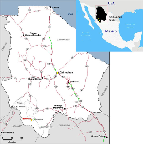
Mammoth has earned a 100% interest in all four concessions subject to a 2 percent Net Smelter Return royalty payable to the vendors of the Mapy, Mapy2 and Fernanda concessions upon commercial production on these concessions. The royalty can be purchased by Mammoth at any time within a three year period from commencement of commercial production for US$1,500,000.
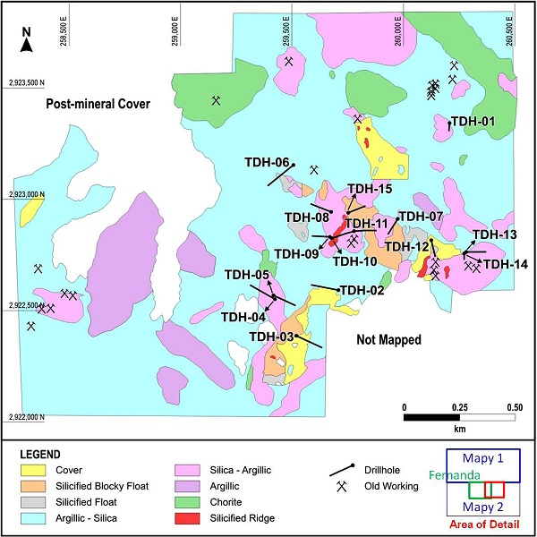
Previous exploration activity on the property included the expenditure of $2.0 million during 2007-2008 by Masuparia Gold Corporation (the previous optioning party), including an initial 15 diamond drill holes totaling 2,566 metres. (all of the core from this drilling is available at the on-site exploration camp) and 2,586 geochemical soil and rock chip samples. Diamond drill locations are illustrated in the following map: Drill Hole Location Map, Masuparia Gold Diamond Drilling (2009), Tenoriba Property.
Drill Hole Location Map, Masuparia Gold Diamond Drilling (2009), Tenoriba Property
Some of the most attractive intersections from this 2008 drill program can be seen in the following table of drill results.
| Drill Hole Number |
From | To | Interval Length | Gold (Fire Assay) |
|---|---|---|---|---|
| (metres) | (metres) | (metres) | (gpt) | |
| TDH-01 | 3.50 | 14.70 | 11.20 | 0.54 |
| TDH-07 | 35.00 | 51.00 | 16.00 | 0.49 |
| 61.00 | 64.70 | 3.70 | 5.33 | |
| (including) | 62.80 | 64.70 | 1.90 | 45.90 |
| 120.50 | 132.00 | 11.50 | 2.26 | |
| (including) | 129.50 | 132.00 | 2.50 | 9.21 |
| TDH-11 | 27.30 | 67.00 | 39.70 | 0.48 |
| 40.80 | 49.00 | 8.20 | 1.45 | |
| (including) | 110.00 | 144.40 | 34.40 | 1.03 |
| 116.80 | 124.20 | 7.40 | 2.82 | |
| (including) | 135.00 | 144.40 | 9.40 | 1.37 |
| TDH-12 | 21.00 | 46.60 | 25.60 | 0.56 |
Note: Results were contained in a press release by Masuparia Gold Corporation on June 25, 2008 (refer to Sedar, Masuparia Gold Corporation) and were approved by Masuparia's QP and met industry QC standards. High grade samples - samples exceeding 10 gpt gold were cut to 10 gpt gold in any composite intersections.
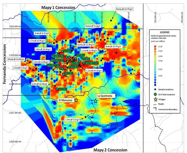
Preliminary results from the company's efforts to consolidate the historical data generated at Tenoriba by Masuparia highlighted the presence of a large irregular shaped approximately 5.0 kilometre by 3.0 kilometres, generally east -- west striking soil gold anomaly with numerous surface rock samples assaying greater than 5.0 gram per tonne (g/t) gold up to as high as 23.50 g/t gold (refer to Figure -- Surface Rock Sample and Colour Contoured Gold Soil Map of the Tenoriba Property). The consolidation work was performed mainly from Masupari's 2007-2008 exploration program which includes 1,893 soil samples, 90 stream samples and 686 rock surface samples.
Surface Rock Sample and Colour Contoured Gold Soil Map of the Tenoriba Property
(surface rock samples illustrated as length of sample or sample type and assay results in grams per tonne gold)
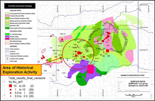
In mid January 2013, the company received assay results from samples taken from its first two exploration campaigns by its geological team exploring Tenoriba. The best result from this campaign assayed 23.6 grams per tonne (gpt) gold and 62.1 gpt silver, or 24.84 gpt gold equivalent (using a ratio of 50 gpt silver is equivalent to 1.0 gpt gold based on current gold and silver prices). This single highest gold assay was followed by 26 other samples that exceeded more than 2.0 gpt gold equivalent, 45 results that exceeded 1.0 gpt gold and 85 samples that were anomalous exceeding 0.3 gpt gold equivalent, of a total of 219 samples collected.
Furthermore, many of these samples came from areas where mapping and sampling of similarly altered felsic volcanics and breccia with numerous locations of vuggy silica occurred as much as one kilometre to the northeast and to the southwest of the area of focused exploration and drilling by the previous optionor, Masuparia Gold Corporation (Masuparia), where Masuparia assayed up to 45 grams per tonne gold.
During these two exploration campaigns 219 surface rock samples and 7 stream sediments samples have been collected over selected accessible portions of an approximate 12 square kilometre area (an approximate 3 kilometre by 4 kilometre area). In addition, 44 surface and core samples have been selected for Xray Fluorescence analysis to identify the type of clays present in the altered Tertiary felsic volcanic.
Overall, the field work to date has confirmed Masuparia's previous geological observations, including the presence of a large area extending over numerous square kilometres of altered Tertiary felsic volcanics intruded by diorite, quartz monzonitic and quartz feldspar intrusives. Unsorted volcanic breccias have been observed by the Mammoth team to be much more common throughout the volcanic pile than previously reported.
Summary Table of Assay Results Exceeding 2.0 gpt Gold Equivalent
| Sample Number |
Sample Method |
Sample Interval/Area (m) |
Au (gpt) |
Ag (gpt) |
Au Eq (gpt) |
|---|---|---|---|---|---|
| 330002 | chip | 0.4 | 23.60 | 62.1 | 24.84 |
| 330003 | chip | 0.6 | 3.74 | 12.3 | 3.99 |
| 330006 | grab | 8.36 | 18.4 | 8.73 | |
| 330014 | grab | 6.17 | 7.8 | 6.33 | |
| 330015 | grab | 1.0 x 2.5 | 0.37 | 235.0 | 5.07 |
| 330028 | dump | 4.33 | 2.7 | 4.38 | |
| 330043 | chip | 0.4 | 1.05 | 42.9 | 1.91 |
| 330044 | chip | 1.0 | 1.16 | 39.7 | 1.95 |
| 330045 | chip | 1.5 | 0.53 | 51.9 | 1.57 |
| 330046 | chip | 1.5 | 0.70 | 63.0 | 1.96 |
| 330068 | chip | 1.5 | 1.04 | 30.0 | 1.64 |
| 330071 | chip | 1.5 | 1.67 | 68.2 | 3.03 |
| 330108 | chip | 1.5 | 0.62 | 97.0 | 2.56 |
| 330143 | grab | 0.77 | 106.0 | 2.89 | |
| 330149 | grab | 5.71 | 4.0 | 5.79 | |
| 330168 | grab | 1.61 | 24.2 | 2.09 | |
| 330177 | chip | 1.0 | 11.90 | 15.5 | 12.21 |
| 330186 | chip | 1.7 | 3.50 | 44.1 | 4.38 |
| 330187 | chip | 1.0 | 5.10 | 42.3 | 5.95 |
| 330189 | chip | 1.0 | 1.75 | 42.1 | 2.59 |
| 330192 | chip | 1.0 | 1.40 | 29.6 | 1.99 |
| 330197 | chip | 1.5 | 3.84 | 8.6 | 4.01 |
| 330199 | chip | 1.0 | 2.16 | 17.1 | 2.50 |
| 330201 | chip | 1.0 | 2.17 | 11.2 | 2.39 |
| 330203 | chip | 0.6 | 1.21 | 68.5 | 2.58 |
| 330226 | chip | 1.5 | 2.12 | 36.5 | 2.85 |
| TEN-12 | chip | 1.5 | 2.83 | 36.8 | 3.57 |
Sample Location Map
For additional and more recent information on the Tenoriba project please refer to this same "Projects" section of the website, "Technical Reports" and company news releases.