Toronto, Canada (October 24, 2013) - Mammoth Resources Corp. (TSX-V: MTH) is pleased to announce that is has begun a ground Induced Polarization (IP) and Magnetometer (Mag) geophysical survey over select areas of the company's Tenoriba property, located in the prolific Sierra Madre precious metal belt in south western Chihuahua state, Mexico (refer to the company's web site www.mammothresources.ca, for a detailed location map).
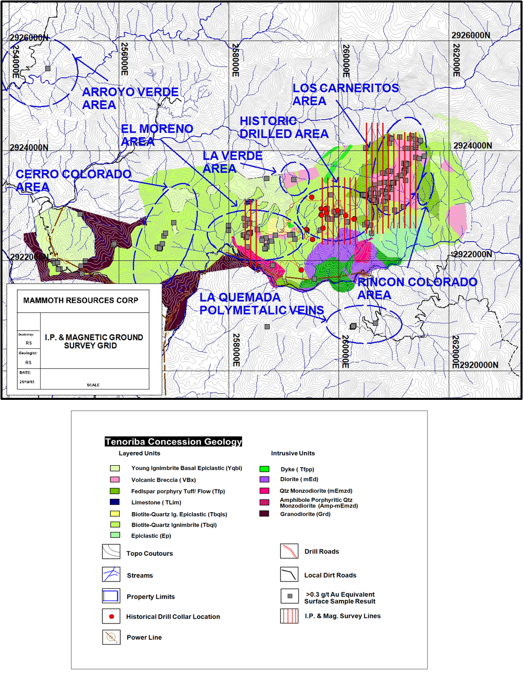
The company has selected areas comprising approximately half of the large 15 square kilometre area of the property in which it has mapped and sampled various high sulphidation gold features with numerous sample values in excess of 0.3 grams per tonne (gpt) gold and silver. The survey also covers the area previously drilled by Masuparia Gold Corporation In 2007-2008 in which they reported: "All fifteen drill holes intersected anomalous gold values, often over wide intervals" with the company highlighting intersections in 10 of 15 drill holes, the highest grade being a 1.9 metre intersection in drill hole TDH-07 grading 45.9 gpt gold and the longest mineralized intersection being a 66.0 metre intersection in drill hole TDH-14 averaging 0.50 gpt gold (refer to Sedar, Masuparia Gold Corporation filing June 30, 2008). Total length of surveyed lines is approximately 32 kilometres (refer to Figure 1. Geophysics Survey Location Map).
Thomas Atkins, President and CEO of Mammoth Resources commented on these results, stating: "We've designed the survey to cover approximately half of the area in which we've mapped and sampled the best precious metal values. However, as we're testing the application of the geophysics in delineating these surface features at depth, we've chosen at this time and until we know of the effectiveness of the geophysics, to refrain from covering the entire 15 square kilometre area of mineralization. We've included the area previously drilled by Masuparia in the survey in order that we might determine the extent of the features Masuparia intersected with their drilling, plus any extensions or trends to these features, prior to drill testing any such extensions ourselves. Our hope is that the survey will identify at depth the features we've mapped and sampled at on the surface at Carneritos and El Moreno, plus those drilled by Masuparia and allow us to better target such features to be drill tested following interpretation of the results of the geophysics."
Mammoth expects to complete the survey by the end of November with the interpretation of survey results to follow soon thereafter. The company will report on these survey results once available.
In separate news the company has issued another $45,250 in Units of it's previously announced (refer to press release dated September 10, 2013) private placement financing bringing the total proceeds from this financing to $599,370 of its $600,000 objective.
Qualified Person / Quality Controls:
Richard Simpson, P.Geo., Vice-President Exploration for Mammoth Resources Corp. is Mammoth's Qualified Person, according to National Instrument 43-101, for the Tenoriba property and is responsible for and has reviewed any technical data mentioned in this news release.
About Mammoth Resources:
Mammoth Resources (TSX-V: MTH) is a mineral exploration company focused on acquiring and defining precious metal resources in Mexico and other attractive mining friendly jurisdictions in the Americas. The Company has an option to acquire 100% in the Tenoriba Property located in the Sierra Madre Precious Metal Belt in southwestern Chihuahua State, Mexico. The company continues to seek other option agreements in the Americas on other properties it deems to host above average potential for economic concentrations of precious metals mineralization.
To find out more about Mammoth Resources and to sign up to receive future press releases, please visit the company's website at www.mammothresources.ca.
Neither the TSX Venture Exchange nor its Regulation Services Provider (as that term is defined in the policies of the TSX Venture Exchange) accepts responsibility for the adequacy or accuracy of this release.
Forward Looking Information: This news release may contain or refer to forward-looking information. All information other than statements of historical fact that address activities, events or developments that the Company believes, expects or anticipates will or may occur in the future are forward-looking statements; examples include the listing of its shares on a stock exchange and establishing mineral resources. These forward-looking statements are subject to a variety of risks and uncertainties beyond the Company's ability to control or predict that may cause actual events or results to differ materially from those discussed in such forward-looking statements. Any forward-looking statement speaks only as of the date on which it is made and, except as may be required by applicable securities laws, the Company disclaims any intent or obligation to update any forward-looking statement, whether as a result of new information, future events or results or otherwise. Although the Company believes that the assumptions inherent in the forward-looking statements are reasonable, forward-looking statements are not guarantees of future performance and, accordingly, undue reliance should not be placed on these forward-looking statements due to the inherent uncertainty therein.
For further information please contact:
Thomas Atkins
President & CEO
tom@mammothresources.ca
Figure 1. Geophysics Survey Location Map
(red lines on map represent geophysical survey lines -- refer to legend for additional details)