Toronto, Canada (October 25, 2017) - Mammoth Resources Corp. (TSX-V: MTH), (the "Company"), is pleased to announce a diamond drill program from 8 to 24 high priority targets planned to commence in November 2017 on its Tenoriba gold-silver property in Chihuahua State, Mexico (the project was drilled by a predecessor company in 2008 which reported gold intersections in 10 of 15 holes drilled).
Mammoth has targeted its drill holes based on what it believes is a compelling combination of: (1) surface geology, (2) trace element geochemistry, (3) gold bearing samples from chip and cut channels over a large 15 square kilometre area of gold mineralization, (4) PIMA sampling results indicating proximity to high temperature geothermal activity coincident with surface gold values, and (5) a ground Induced Polarization (IP) and Magnetometer (Mag) geophysics survey which illustrates attractive geophysical features at depth coincident with surface gold mineralization, artisanal workings and in some cases intersected at depth by a predecessor company's drilling (the highest grade intersection assaying 45.9 grams/tonne gold over 1.9 metres in drill hole 7 and the lengthiest gold intersection assaying 34.4 metres grading 1.03 grams/tonne gold in drill hole 11 and 66 metres grading 0.5 grams/tonne gold in drill hole 14) (for additional information on these results please feel free to reference the technical reports available on the Company's website at the following link: TechReports.). Mammoth intends to post a technical report on its drill target selection at the same "Technical Reports" location on the website in the coming days. A number of these drill hole locations are discussed and illustrated in the following commentary.
Thomas Atkins, President and CEO of Mammoth commented on the drill targeting stating: "We've completed the consolidation of all surface results from the various exploration activities on the property. This work has enabled Mammoth to identify what we feel are the most compelling drill targets to test gold mineralization over an approximate 6-kilometre strike length of surface gold mineralization within the High Sulphidation, precious metal mineralizing system at Tenoriba.
A unique feature to some of the proposed targets is they occur as extensions or within geological features where prior drilling intersected gold over tens of metres. At the time of the earlier drilling, those undertaking this drilling didn't have the benefit of the geophysics survey recently completed by Mammoth. The geophysics survey which covers half of the property gives information on the characteristics of the geology below surface in areas where favourable surface geology and hundreds of gold samples have been collected over a large 15 square kilometre area of mineralization, the highest grade of which assayed 74 grams/tonne gold, with another approximate 10 samples averaging from 10 to 47 grams/tonne gold.
Mammoth believes there is excellent potential for success in the proposed drill program given the combination of the surface geology and gold values correlating with geophysical features at depth, and especially where earlier drilling intersected gold over tens of metres in similar geophysical features as those targeted in the Company's proposed program."
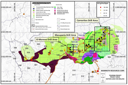
The Company plans to drill from 3 to 7 diamond drill holes in each of the El Moreno and Masuparia areas and from 5 to 10 drill holes in the Carneritos area for a total of from 8 to 24 high priority drill holes (refer to drill collar locations; black being top priority drill locations and grey additional high priority targets in Figure 1 - Surface Plan, Proposed Drill Collar Locations). The Tenoriba project is fully permitted with surface access agreements in place for the immediate commencement of drilling. The drill contractor has been selected and is finalizing details of mobilization to the project area and has elected to accept up to 60% of the cost of the proposed program (to a maximum of less than 10% of the outstanding shares of the company) in shares of Mammoth, subject to TSX approval.
Petrographic analysis of gold at Tenoriba indicates its occurrence as free gold. Bottle roll testing on samples collected at various depths and grades from drill core from the prior drilling resulted in 100% gold recovery in less than 24 hours to a vertical depth of 60 metres and recoveries of 65% to 70% in 72 hours to depths of 125 metres (the deepest core depth available). Subject to more extensive testing and verification it would appear from these results that gold at Tenoriba may be recoverable by low cost heap leaching methods implying the potential that should an economic resource be discovered at Tenoriba this resource may be amenable to low cost open pit mining and heap leach gold recovery.
Masuparia Area Drill Targets:
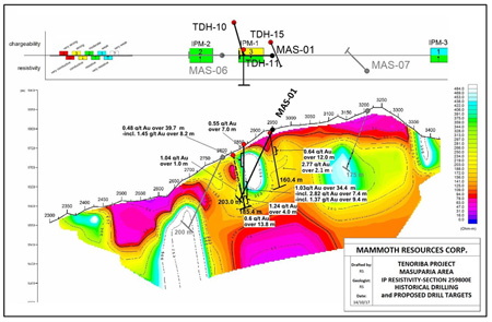
From 3 to 7 drill holes are targeted in the Masuparia area located near the middle of the approximate 6-kilometre trend of gold mineralization at Tenoriba (refer to Figure 1). Section 259800E - IP resistivity geophysics section (refer to Figure 2 - Masuparia Area IP Resistivity Section with Historical and Proposed Drilling), illustrates the trace of the proposed drill hole MAS-01 together with prior drilling (another 2 high priority drill holes are planned for this area). The areas of highest initial interest within the 600 metres east-west area covered by the geophysics survey is focused on gaps near prior drilling within and along an approximate 750 m long northwest trending corridor of gold mineralization and where there are a number of artisanal workings, portions of which were intersected by 7 prior drill holes, including TDH 11 and 15 along this section in which TDH 11 intersected 39.7 metres grading 0.44 g/t gold and 34.4 metres grading 1.03 g/t gold and TDH 15 intersected 12 metres grading 0.64 g/t gold in areas indicated by high resistivity in the IP geophysics.
El Moreno Area Drill Targets:
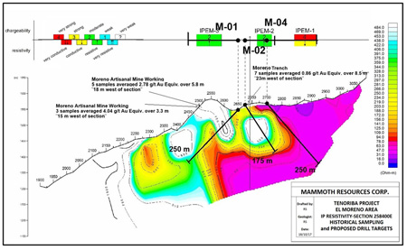
From 3 to 7 drill holes are targeted in the El Moreno area located approximately one kilometre east of the western end of the 6-kilometre trend of gold mineralization at Tenoriba (refer to Figure 1). Section 258400E - IP resistivity geophysics section (refer to Figure 3 -- El Moreno Area IP Resistivity Section with Historical Sampling and Proposed Drilling), illustrates the trace of proposed drill holes M-01, M-02 and M-04 testing high resistivity (white through light blue to light yellow colours on section) targets to depths of in excess of 100 to 200 metres where surface geology, sampling results, including 5.8 metres grading 2.78 g/t gold, 3.3 metres grading 4.04 g/t gold and an 8.5 metre long channel which averaged 0.86 g/t gold and extensive artisanal workings are prominent. Another diamond drill hole 100 metres east of these holes will result in a total of 200 metres of strike length being tested in this area, the surface and geophysical features remain open to the east towards the Masuparia area while to the west these features could extend at least one kilometre to the Cerro Colorado area where gold has also been sampled on surface.
Los Carneritos Area Drill Targets:
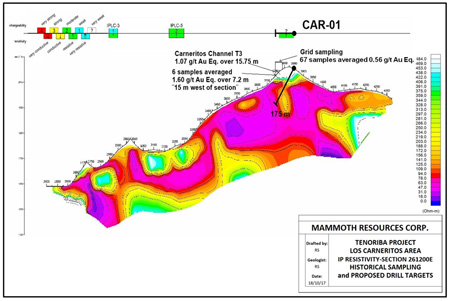
From 5 to 10 drill holes are targeted in the Los Carneritos area located at the eastern end of the 6- kilometre trend of gold mineralization at Tenoriba (refer to Figure 1). Section 261200E - IP resistivity geophysics section (refer to Figure 4 - Los Carneritos Area IP Resistivity Section with Historical Sampling and Proposed Drilling), illustrates the trace of proposed drill hole CAR-01 testing high resistivity (white through light blue to light yellow colours on section) from surface to a vertical depth of approximately 150 metres where favourable surface geology and sampling results, including: 15.75 metres grading 1.07 g/t gold, 7.2 metres grading 1.6 g/t gold and a 5 by 5 metre 67 sample grid averaged 0.56 g/t gold. Another 4 top priority diamond drill holes are targeted for this area and another 5 high priority targets are planned to test an area approximately 600 by 1,200 metres in this area to depths of in excess of 100 metres.
Richard Simpson, P.Geo., Vice-President Exploration for Mammoth Resources Corp. is Mammoth's Qualified Person, according to National Instrument 43-101, for the Tenoriba property and is responsible for and has approved all scientific and technical data mentioned in this news release.
To find out more about Mammoth Resources and to sign up to receive future press releases, please visit the company's website at: www.mammothresources.ca, or contact: Thomas Atkins tel:416-509-4326, or: tr_atkins@rogers.com
Neither the TSX Venture Exchange nor its Regulation Services Provider (as that term is defined in the policies of the TSX Venture Exchange) accepts responsibility for the adequacy or accuracy of this release.
Forward Looking Information: This news release may contain or refer to forward-looking information. All information other than statements of historical fact that address activities, events or developments that the Company believes, expects or anticipates will or may occur in the future are forward-looking statements; examples include the listing of its shares on a stock exchange and establishing mineral resources. These forward-looking statements are subject to a variety of risks and uncertainties beyond the Company's ability to control or predict that may cause actual events or results to differ materially from those discussed in such forward-looking statements. Any forward-looking statement speaks only as of the date on which it is made and, except as may be required by applicable securities laws, the Company disclaims any intent or obligation to update any forward-looking statement, whether as a result of new information, future events or results or otherwise. Although the Company believes that the assumptions inherent in the forward-looking statements are reasonable, forward-looking statements are not guarantees of future performance and, accordingly, undue reliance should not be placed on these forward-looking statements due to the inherent uncertainty therein.
Figure 1 - Surface Plan, Proposed Drill Collar Locations

Figure 2 - Masuparia Area IP Resistivity Section with Historical and Proposed Drilling

Figure 3 - El Moreno Area IP Resistivity Section with Historical Sampling and Proposed Drilling

Figure 4 - Los Carneritos Area IP Resistivity Section with Historical Sampling and Proposed Drilling

